After previous refusals trustees are making a renewed bid to get approval to redevelop Whalebones estate
Yet another revised scheme to build houses and flats on the woods and farmland at Whalebones in Wood Street, High Barnet, has been shown to local residents at a public exhibition held by the estate’s trustees and their developers Hill Residential.
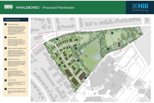
After losing a planning appeal last year, the proposed number of new homes has been cut from 152 to 118 with the result that an additional acre of land would now remain undeveloped and kept as green open space.
Hill say the scale of the redevelopment — as shown in the illustration above — has been reduced by:
Abandoning the plan to build houses in the triangular field at the junction of Wood Street and Wellhouse Lane.
Increasing the depth of the green buffer between Wood Street and the edge of the new estate (opposite the Arkley public house).
Widening the green space between the existing privately-owned Grade II listed Whalebones House and the new properties.
Barnet Council indicated almost a decade ago that it intended to permit housing development within the 14-acre Whalebones site which is inside the Wood Street conservation area and which, with its mature and protected trees, provides a green buffer between Arkley and High Barnet and between Wood Street and Barnet Hospital.
But the various schemes proposed so far have met concerted local opposition.
These latest changes are designed to meet the concerns of a planning inspector who rejected the plan for 152 homes on the grounds that the benefit of residential development did not overcome the weight of harm to important heritage assets.
Richard Powles, one of the trustees of the Gwyneth Cowing Will Trust, told the Barnet Society that they had listened to what was said by both the planning inspector and nearby residents, and they had taken action to adjust their plans.
After this latest round of local consultation, and the plans can be inspected and
feedback given via a dedicated website https://whalebones-consultation.co.uk/
Hill will prepare a detailed planning application for submission to the council.
Among the local groups consulted by the developers are the Barnet Society and the Barnet Residents Association.
In preparing its response, the society proposes to examine the plans in detail and canvass the opinions of members before deciding what action to take.
At the exhibition of the plans, Henry James, a senior development manager at Hill Residential, told residents of significant changes since the previous proposal.
New detached houses that would front Wood Street had been moved further back from the road and three five-storey apartment blocks moved further south towards Wellhouse Lane and further away from properties in the new Elmbank estate.
By widening the green buffers fronting both Wood Street and alongside Whalebones House, and by removing the plan for five houses in the field at the corner of Wood Street and Wellhouse Lane, almost half of the 10.5 acres within the scheme would now remain as open space – an acre more than before.
Open spaces would remain undeveloped in perpetuity and would be transferred to a land management company which would be financed partly through a cash injection from the trustees and service charges on householders on the estate.
Entrance to the development would be via an approach road opposite the Arkley public house – with a new T junction with Wood Street – and this would provide access through the development to Wellhouse Lane for cyclists and pedestrians, but not vehicles.
There would be two other footpaths from Wood Street to Wellhouse Lane through the Whalebones woods and fields:
A woodland walk starting opposite the Wood Street junction with Argyle Road.
A footpath starting in Wood Street (midway between the bus stop and the Whalebones arch) that would lead directly to the Barnet Hospital bus terminus.
Under the scheme 40 per cent of the homes – mostly in the three apartment blocks – would be designated as affordable, with a mix of rent and shared ownership properties.
As previously proposed, Hill have undertaken to build a new community building fronting onto Wellhouse Lane with a studio for the Barnet Guild of Artists and facilities for the Barnet Beekeepers Association.
In the Wood Street/Wellhouse Lane corner of the site Well Cottage, the home of tenant farmer Peter Mason and his wife Jill, agricultural land would be set aside to replace the site of their existing smallholding.
4 thoughts on “After previous refusals trustees are making a renewed bid to get approval to redevelop Whalebones estate”
Comments are closed.

Why not become a member? Receive our latest newsletter hot off the press four times a year, and support our work with a membership.
If you have some local news, history or want to bring something to our attention please email us.
NEW: 🏆 The Mitre wins 🍺 award for Barnet and Enfield
NEW: Macbeth is coming to Barnet 🏴
Message from Dean! 📩
Join us at The Hive on Sunday 6th July for our FREE Annual Community Day! 🎉
🏆 Meet the Champions
🤪 Face Painting
🎷 Live Music
🏴☠️ Player Treasure Hunt
⚽️ Football Tournament
🐝 Fun for the whole family!
#BarnetFC🐝
NEW Armed Forces Day at the St Albans Road centre
My previous comment on the use of the west field and the footpath across it has been removed at my request. While based on two independent accounts and maps I asked for more research. Further maps have been found extending the timeframe of the use of the field divided into plots for food growing. That can now be shown to be from something between around 1910 to 1970. I apologise for that error.
However the comment on this issue in the consultation documents still cannot reasonably justify the development of that land by in someway not defining it as urban green space and in someway not continuous with the rest of the estate:
“The land to the west has a distinctly different character having previously been allotments and in separate ownership until more recently”.
I would observe the status of the land is currently fallow pasture, grassland indistinguishable from grassland elsewhere on the estate as it has been for the last 50 odd years. Previous variations in its agricultural use have no bearing on the land’s present environmental value adding to the size of this green open space. However it is clear this will be a technical argument made with some force as part of any planning application.
While the appellant’s representatives at the Inquiry stated categorically that there was never a public footpath across the estate this is equivocation – technically true but deeply misleading. The path in the west field shown on numerous maps and in widespread recollection was a permissive footpath, a category of path the public are allowed to use at the landowners discretion. During living memory and testimony this was kept open on the orders of Miss Cowing during her lifetime and with instructions it should continue to be used in this way after her passing.
This continued until the 2001 Foot and Mouth outbreak when footpaths across agricultural land were temporarily closed by local authorities on instructions from the government. However after restrictions were lifted the Trust gave instructions at an annual tenants meeting that the path should remain closed permanently. The Trustees had full legal authority to do this as Miss Cowing’s last will gave them absolute discretion in the management and disposal of the estate. It imposed no legal duty on them to respect Miss Cowing’s instructions on this or anything else.
However it is now suggested the lack of public access through the absence of a path and the reduction of community groups using the site is justification for the land being developed. As such public access is at the pleasure of the Trust that may seem unreasonable.
Once you start developing on green space, it may lay some precedent on future development on green areas, widening Barnet town into countryside. Retaining existing open space around Chipping Banet is vital.
How about restoring Allotments for the people on the original allotment area, putting land to use that Miss Cowing intended for the benefit of the residents.
Make it just a little more visible to people to inform them of the space and want to appreciate it, formerly so enclosed.
The new consultation repeats and compounds a false claim made and refuted at the appeal.
“The land to the west has a distinctly different character having previously been allotments and in separate ownership until more recently”.
To suggest the field only became part of Whalebones after 1946 and converted to pasture from long historical use as allotments is simply untrue and misleading.
In 1939 the field was temporarily divided not into allotments (usually of 25 square metres) but regulation sized “Standard Plots” of some 250 sq metres, about the size of two tennis courts, for the Dig for Victory campaign. then subdivided into transverse strips by users for different food crops. This arrangement is clearly visible in the aerial photograph taken in 1946 displayed at the consultation.
Aside from this emergency use the fields had been pasture for the estate since it was created in the early 19th century, further back being open land and still pasture.
Miss Cowing was a pioneer and strong supporter of the Dig for Victory campaign and used her extensive contacts to help set it up. This saw open land including public parks and suitable farmland temporarily given over to local people to grow food during food shortages caused by the Second World War.
This was through a combination of voluntary and compulsory agreements with landowners. Miss Cowing not only volunteered her land for this use but with many other farmers allowed this to continue until 1952 and the abolition of most rationing. At that time the field was re-instated as pasture as it had been through its pervious history. The regulations specifically prohibited landowners considering use during the food shortages as change of use.
The different character claim is another misdirection. it was greatly valued by the people of High Barnet for not only for being the last significant field in the town but also something they could enjoy using the historical permissive/concessionary footpath for public use down the middle of the field. This path is also shown clearly not only on the photograph now on the consultation website but also on historic maps.
Miss Cowing left instructions to her tenants that this path should be kept open during her lifetime and after it, closed just two days a year so she could apply conditions on its use such as keeping dogs on a lead. However after it was temporarily closed by government order in the 2002 Foot and Mouth crisis it never reopened . When the government advised footpaths on pasture should be reopened the Trust instructed it remain permanently closed.
The only reason to remove the path was to reduce public access and enjoyment of the land. This is a key part of the construction of the narrative that Whalebones has no public access and hence does not deserve protection.
It should be impossible to see how approving this scheme would fit in with our recently elected council’s green policies. These include a net zero carbon future and supporting the Barnet Green Spaces Network Manifesto which pledges to “protect ALL green open spaces in the borough”. This high above sea level no one is making any more of it.
That manifesto also declares,”no green space can now be deemed to be of either low quality or low value.” Such a low value as green space and lack of public access are somehow arguments used to justify this development. These are issues the Trust that manages the Whalebones estate is responsible for. To re–float the finances of the Trust and resolve these issues would only take fewer than ten new properties as an enabling development, not up to 120.
I truly understand the need for housing and particularly truly affordable and social housing, I have called for more of the latter two all of my adult life. But I am saddened and quite frankly alarmed that this need should be used as justification to build on land which should be protected by many of the people who should be protecting it.
As has been shown as near as Finchley Memorial Hospital promises of green urban space being given to public use in perpetuity can be completely worthless. As at Finchley this is on the strongest balance of probability just delayed development of the whole site (except for the listed Whalebones House) in just one more bite sized chunk.
There is nothing new to redeem this project. However I have some expectation council officers instruct the committee that a refusal could not be defended on appeal. They said exactly the same when the previous application was refused. They were wrong then, they would be wrong again.
The movement of the building line back from Wood Street is minimal and unlikely to be noticeable despite the gentle slope of the land. The new consultation makes much of the this change but does not produce an artwork view to support it. The projected bulk as seen from Wellhouse Lane would be extreme. The moving of new buildings further from listed buildings is insignificant. The reduction of impact on properties in Elmbank is only at one end.
The revisions simply do not resolve the issues for which the appeal was rejected and for which it faced so much local opposition.